Save Beautiful Del Puerto Canyon! Del Puerto Canyon Should be Parks and Ranchlands!
Del Puerto Canyon is at risk of being destroyed by the Del Puerto Water District’s proposed reservoir project. Sign this petition to say no to the ridiculous and costly Del Puerto Reservoir project. Del Puerto Canyon should be parks and ranchlands!
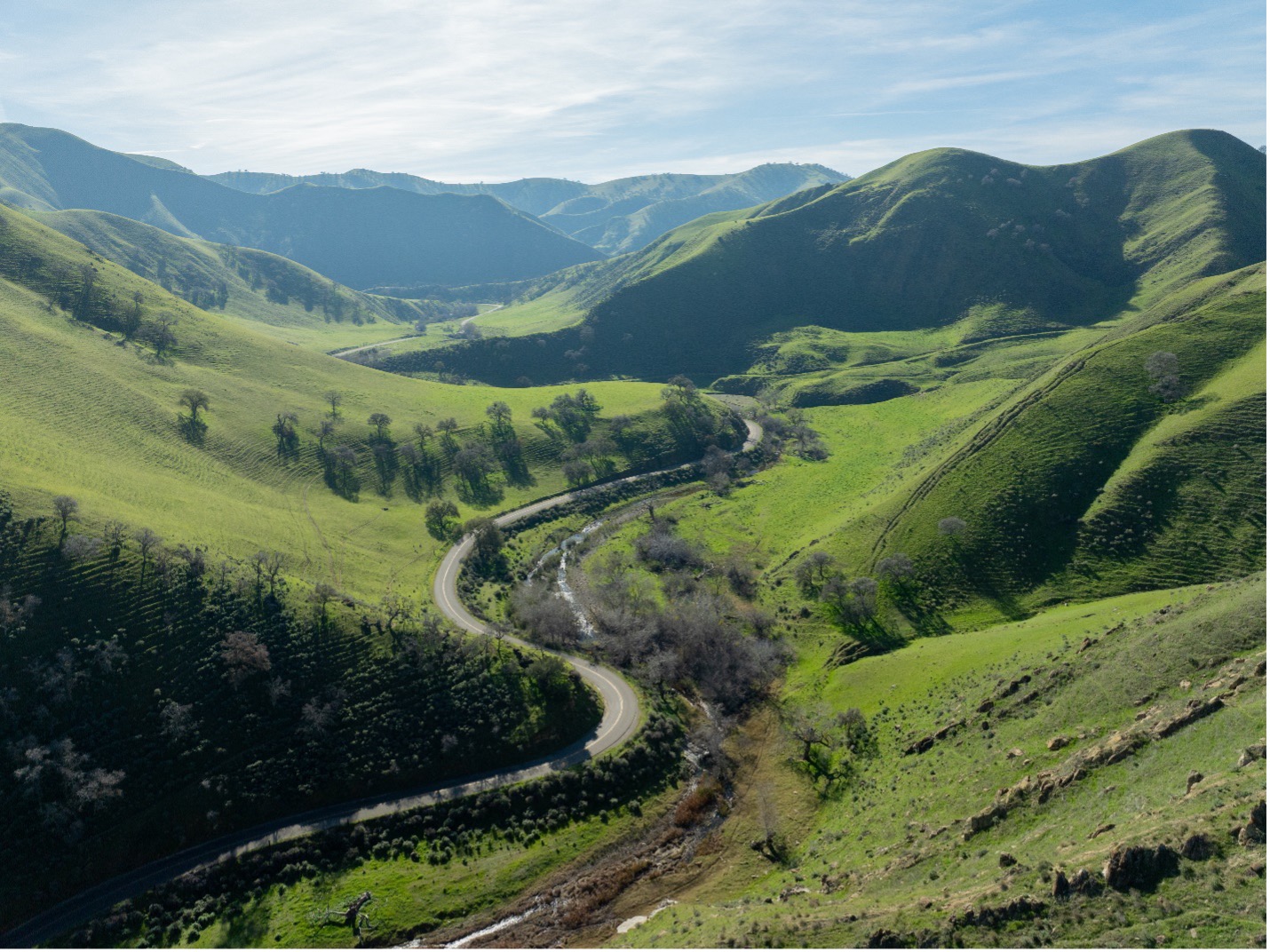
The beautiful and irreplaceable canyon is proposed to be flooded underneath a 260-foot-tall dam. The Gateway entrance along with the first five miles of the canyon would all be destroyed.
The Del Puerto Water District would use the reservoir to store non-drinkable water over tens of thousands of acre-feet, which would mean no recreational access to the area, lasting impacts to surrounding ranchlands, and destruction of rare wildlife habitat.
The historic roadway would also have to be re-routed away from the proposed reservoir. The construction of the roadway will have astronomical costs and hasn’t found reliable funding. The cost of the reservoir project as a whole has tripled in seven years from $400-$500 million to $1.2 billion. Ratepayers and taxpayers will end up footing the bill at a time when families are already struggling with higher costs.
This is not a drinking water project. Most of the water will be used to irrigate farms far from Patterson. Water conservation and ground water storage are better, cheaper alternatives.
If built, water from the Del Puerto Reservoir would envelop an area of the Del Puerto Creek drainage that is known to have active landslides. The Del Puerto Water District’s plans also show the dam would be built along the San Joaquin fault line, adding increased concern towards the structural integrity of the project.
Interstate 5, the California Aqueduct, and the Delta Mendota Canal would be in danger of being washed away if there was a catastrophic failure of the dam, not to mention the risk of massive flooding that could tragically impact residents of Patterson.
The Patterson City Parks and Recreation Department, as well as previous city leaders, have all recognized the Gateway as an area of great cultural and ecological significance.
They've called for preservation of the area with recreational access for horseback riding, hiking, and mountain biking, as well as plans for an outdoor amphitheater.
Opposition to the proposed Del Puerto Reservoir is growing as residents are becoming more aware of the hazards posed by the dam. Many are appalled at the potential loss of this natural treasure.
Del Puerto should be a park with expanded recreational access as previously approved by the Patterson Parks and Recreation Commission. The canyon should also be protected to preserve ranchlands and the ranching way of life.
Why should the small Del Puerto Water District with just seven people making decisions be able to destroy this magnificent place and interfere with Patterson's pre-existing plans for a community park?
The beauty of the canyon is irreplaceable.
The first five miles of Del Puerto Canyon with its steep rolling hills and perennial wildflowers of every color are among the most spectacular views in California.
Bobcats and mountain lions have been seen here, as well as burrowing owls, badgers, and countless other animals, including evidence of the endangered San Joaquin kit fox. One of the largest nesting populations of golden eagles in the world resides right through the Gateway. A dam would cut water flows in Del Puerto Creek by more than 80 percent, which means less water for this wildlife.
Native American cultural sites, such as grinding stones, pathways, and burial sites, reside in the inundation zone. Sacred cottonwood trees that are the last living link to the Hoyumne and Miumne Yokuts, would be cut down.
The reservoir is not a done deal, its old Environmental Impact Report (EIR) was voided in court, and the new EIR is currently in the review period but is riddled with flaws. Many rare wildlife species weren’t even considered in the environmental review.
The Stanislaus County Board of Supervisors still has authority over key land use decisions related to this project and a duty to represent all county residents, not just those served by the Water District.
Regional leaders, including congressional representatives, should also deny funding for the dam.
Please send a letter to local and regional decision makers and urge them to oppose the proposed Del Puerto Reservoir and dam! We must protect Patterson’s backyard. Once it’s underwater, it’s gone forever.
