⛔ Help us in the DWG - This is an emergency! 611 is now closed. We need NJDOT study solutions to the I80 Issues!
New Jersey Department of Transportation
One of our worst fears has just come to fruition. On April 1, 2022, the retaining wall on Route 611 in the DWG eroded to the point where it is now closed indefinitely.
- Lives of residents and travelers are at risk with the route to the nearest ER blocked.
- Every WB crash on I-80, exit 4 to DWG, now has NO detour route to the nearest hospital, commuters, truckers, vacationers & tourists - we are now in big trouble!
- Businesses that rely on this route will suffer greatly, especially those in the Village of the Delaware Water Gap
611 traffic will now divert to residential and farming communities already suffering due to roads not designed for current volumes
Please sign to help push NJDOT to study all the issues in the I-80 S-Curve at the Delaware Water Gap and present a solution that will incorporate reasonable rockfall mitigation into a plan that abates these issues with the least about of impact.
Some of the history of this issue is below for those who wish to read about. Please visit I-80 Rockfall Fence and Safety Concerns at the Delaware Water Gap Coalition | Facebook for the most up to date information on our battle to STOP THE WALL, PRESERVE THE GAP and FIX THE S-CURVE.
It is well known that I-80 through the Delaware Water Gap is a scenic narrow critical regional corridor. The well documented high crash rate has been ignored by the NJDOT and the agencies who approve federal funding. Many of the crash and traffic impacts are not in NJDOT's jurisdiction, they are in Pennsylvania, served by PennDOT with funding overseen by the Lehigh Valley MPO and the Northeast PA MPO. Our region has quietly lived with this reality and the impacts, trusting scarce transportation funds were addressing more urgent matters.
In 2017, when the NJDOT came to town promising to exacerbate these many issues with their questionable 5-year $60+M Rockfall Mitigation Plan "safety" project and not address these known safety S-Curve issues the towns began speaking out. Today Warren County, over twenty-three PA and NJ municipalities, federal and state legislators, and environmental and recreational groups are on record in opposition, expressing concerns and/or supporting community interest for more involvement.
The project is currently scheduled for construction in 2025 and will obliterate the base of Mount Tammany. The feasibility of the traffic control plan to shrink the lanes, remove the shoulders, and divert I-80 traffic to I-78 via PA-33 and I-287 has not been studied. The current plan even goes against the NJDOT's own 2011 Geotechnical Engineering recommendations which stated, "The NJDOT Geotechnical Engineering Unit determined that large-scale rock removal would not be feasible given that the site is located in the Delaware Water Gap National Recreation Area, the roadway width is limited, and there is a lack of suitable long-term alternate parallel routes for Route I-80’s traffic." Everything in this environmentally, culturally and historically sensitive Delaware Water Gap area is hyper complicated for various reasons.
We support the Warren County Board of Commissioners' September 2021 Resolution 420-21:
"Resolution to request the NJDOT initiate a Problem Statement to study the safety, mobility, and congestion issues on I-80 from Exit 4/Columbia to the Delaware Water Gap Bridge"
Listed in the resolution:
- It is well documented that the S-Curve Section of I-80 from mile marker 2.0 to the Delaware Water Gap Bridge, located in Warren County is known to have a high crash rate.
- Current volumes on I-80 average approximately 47,300- 70-500 vehicles per day with 12% heavy trucks while traffic projections show volumes that range between 89,200-132,800 vehicles per day, thereby exacerbating the already compromised safety and congested conditions.
- The NJDOT is responsible to address safety problems on their highway system when they have been identified.
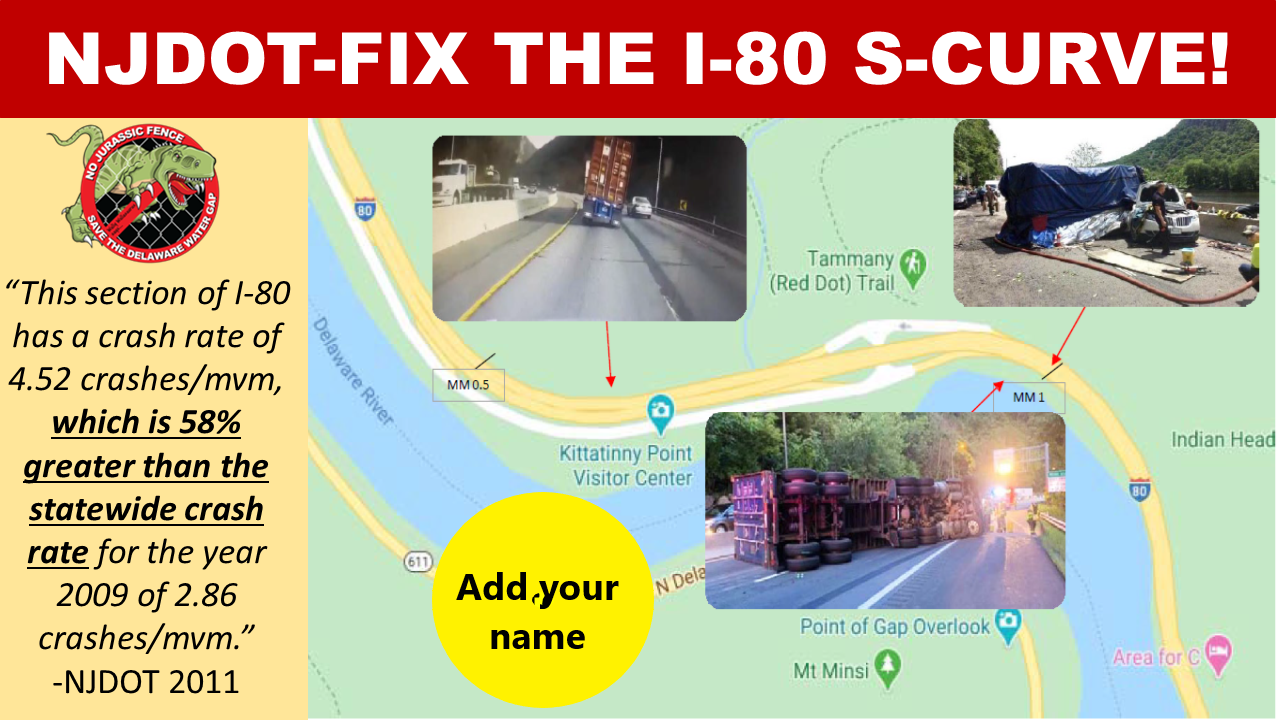
- The I-80 Rockfall Project Purpose and Need Statement noted: NJDOT Bureau of Safety Programs crash data for January 2007 to December 2009 also shows that there are 81 crashes within the project limits for that period This section of I-80 has a crash rate of 4.52 crashes/mvm, which is 58% greater than the statewide crash rate for the year 2009 o/2.86 crashes/mvm; and
- The 2011 NJDOT I-80 Rockfall Concept Development Report noted on page 5: "The Route I-80 roadway carries several safety deficiencies that also contribute to high crash rates. These safety deficiencies include substandard sight distances, narrow shoulder width, and substandard horizontal radii.
- A 2013 Knowlton Township Fire and Rescue (KTFR) and NJ Legislative District 24 (Senator Oroho) correspondence with NJDOT discussed the request for warning signs to be installed for the S-Curve, noting: "emergency personnel have had a few harrowing near-miss situations while operating in this corridor. One situation involved a motor vehicle overturning ·while we were operating on another motor vehicle accident in this corridor. In another recent incident, two tractor trailers one in each of the two lanes side by side, skidded up to the emergency scene, where KTFR personnel were in the process of setting up a safety buffer nearly jack-knifing and colliding into the on-scene personnel".
- A 2018 NJDOT NJSP Accident Report Crash Study Repo1t (2001-2016) which analyzed only a half-mile portion of the 1.5-mile S-Curve noted: 633 motor vehicle accidents, involving three (3) fatalities and 226 injuries
- In July 2020, Knowlton Township formally submitted a Fix The S-Curve NJDOT Transportation Problem Statement request supported with resolutions from Warren County, Hardwick, Portland, Delaware Water Gap, Upper Mount Bethel, Lower Mount Bethel and others seeking a study to identify solutions to all safety, mobility and congestion issues in this section and to conduct a regional traffic study.
- A study compiled by the I80 DWG Coalition using NJDOT, PennDOT and NPS data showing the known safety, mobility and congestion issues in the S-Curve was submitted to NJDOT by Knowlton Township with a Problem Statement request.
- In March 2020, Knowlton Township inquired on the status of the Problem Statement Request and was informed by NJDOT policy had changed and NJDOT was no longer accepting external stakeholder requests, despite the website and posted policy at that time included specific guidelines on how external stakeholders are to submit Transportation Problem Statement Requests that were followed.
- The Warren County Transportation Plan sponsored by the NJTPA Final Presentation noted I-80 S-Curve as the area that received, the most comments (145) and listed I-80 "Safety Improvements on I-80 at the S-Curves" under Policy and Multimodal Recommendations
- The I80 DWG Coalition compiled a list of multi mile traffic events and crashes in the I-80 Delaware Water Gap Area between June 26, 2021, and August 27, 2021 (63 days) from 7:00 am to 8:00 pm with the following results:
- 32days has crashes or 3+ mile traffic back ups
- 9 days had two or more separate crashes or 3+mile traffic events on the same day 30 separate crash events
- 46 separate 3+ mile traffic events
- 23 crashes occurred secondary to an existing traffic back up caused either from Gap/S-Curve volume or a previous crash or in a work zone
- 16 3+ mile traffic jams occurred secondary to a crash
- 6 crashes did not happen in an existing traffic back up or in a work zone 5 separate events closed or jammed both 80W AND 611W at the same time leading to potentially life-threatening EMS delays to the nearest Emergency Room
- 31 days had no crashes or 3+ mile traffic back ups
Thank you! Please contact us if you have any questions.
Tara Mezzanotte, Founding Member I80DWG Coalition - 908-656-4603 I80DWGCoalition@gmail.com
Petition by

Sponsored by

To:
New Jersey Department of Transportation
From:
[Your Name]
One of our worst fears has just come to fruition. On April 1, 2022, the retaining wall on Route 611 in the DWG eroded to the point where it is now closed indefinitely.
-Lives of residents and travelers are at risk with the route to the nearest ER blocked.
-Every WB crash on I-80, exit 4 to DWG, now has NO detour route to the nearest hospital, commenters, truckers, vacationers & tourists - we are now in big trouble!
-Businesses that rely on this route will suffer greatly, especially those in the Village of the Delaware Water Gap
Please study all the safety, mobility, and congestion issues in the S-Curve section of I-80 in the Delaware Water Gap, so solutions can be developed for all of them.
Documents show:
1. Since 2011 you have known this section has been known to have annual crash rates 58% higher than the state average and “The Route I-80 roadway carries several safety deficiencies that also contribute to high crash rates. These safety deficiencies include substandard sight distances, narrow shoulder width, and substandard horizontal radii.” – HNTB 2011 CDR;
2. Since 2013 you have known local EMS were asking for warning signs, concerned about their own safety while tending to the many crashes;
3. Warren County Commissioners, Knowlton & Hardwick Townships, Portland, Delaware Water Gap, Upper Mount Bethel, Lower Mount Bethel, and other neighboring PA municipalities have formally requested you initiate the study.
Any construction in this area will exacerbate the existing issues, so I ask you to pause the current Rockfall Mitigation Plan and incorporate any rockfall mitigation into a larger project that will reasonably address all the known issues and projected future volume with the least amount of impact.
I support Warren County Board of Commissioners' Resolution 420-21, which has been sent to you, requesting a Problem Statement to study the safety, mobility, and congestion issues on I-80 from Exit 4/Columbia to the Delaware Water Gap Bridge.
Thank you!